For my first article, I will take you for a walk in the East-Central Pyrenees, back to a (short) time when I was just thinking about doing my own thing. At the time, I could only go walking on week-ends or holidays, as I was spending the week working in an office -but that was before I started this blog…

A LATE START, BUT A PROMISING ROUTE
Last summer, on a glorious Sunday, I decided to go and explore a part of the Pyrenees called Haute-Ariège. Apart from the Pic des Trois Seigneurs (2199m), I had not had the opportunity to climb any high summit in this area yet. The main local peaks -Pique d’Estats (3143m), Mont Valier (2838m), Pic de Maubermé (2880m), etc…- are attractive for sure, but two days would be needed to reach them. I therefore opted for the Pique Rouge de Bassiès (2676m), which is much more accessible and thus doable on a single day; quite a challenge due to the substantial ascent though. There are several possible starting points. I made my mind for the car park at la Coumebière (ca. 1400m), along the D8f, the road which winds up its way from the village of Aulus-les-Bains to the Col d’Agnès.

Living only about 1h30 driving distance from the first slopes of the Central Pyrenees certainly is an advantage, as I can easily have a day trip to enjoy some summiteering there. But when it comes to reach some further parts of the range, this is another story. After a late start due to a late awakening, I found myself stuck in a traffic jam in the town of St-Girons. Sure I might have fancied staying for the local music festival, but I had something else in mind that day. After a half-an-hour detour which added to the already long drive, here I am at the start of my walk. It is already 11.45am, but there is still plenty of time left and the weather is fantastic.

I have to park alongside the road as the car park at la Coumebière is packed. The walk starts along the famous GR10 marked trail, which I follow in a SE direction for a few hundred metres before taking a right turn. The well-trodden path crosses a bit of forestry until it reaches the ancient Mines des Argentières. Not much time to linger, unfortunately… After the mines, the ground levels, and after about half-an-hour, I reach the Etang de Labant (1597m) where a few walkers stopped to enjoy a picnic. The path then winds up its way through another bit of forestry in a SSW, then W direction before veering SE. A first surprise awaits here. The path now follows a shoulder and as it comes out of the forest suddenly offers fantastic views to the S, across the valley over the rocky ridge which links the Pic de Puntussan (2682m) and the Pique Rouge de Bassiès (2676m, not yet visible), as well as their respective Northern ridges.


REACHING THE MAIN RIDGE
I make my way on the narrow path which runs along the steep, grassy slopes of Les Fouzes. The panoramic views become more and more beautiful despite the modest gain of height. Absorbed by the scenery, I slip stupidly and scratch one knee. Nothing serious, nevertheless it has the unexpected effect of brutally stopping me in my progress. Indeed, after a few minutes’ stop to clean my scratches, I find it hard to get back to finding a proper pace. The weather is getting hot, I have only reached the 1750m contour and there is still a long way to go to the top. I find some motivation imagining the views from the main ridge.


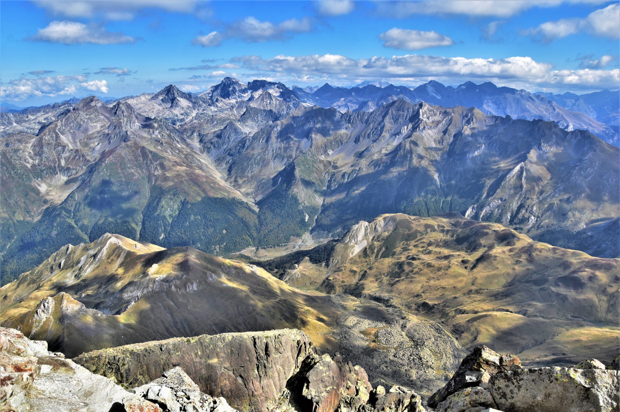
After a while, the ground gets steeper at last and the path becomes a bit more tricky. When I reach the col de las Fouzès (1944m), which links the Pic de Cabanatous (2053m) and the Pic des Planes (2063m), I stand amazed as the views open dramatically to the E over the Etangs (lakes) de Bassiès below and numerous ridges around these and in the distance.


About 50m on my left, a couple of walkers pass by the orri (stone shelter). I cannot stop taking photos, my attention being mostly focused on the deep blue lakes below. I watch the GR10 winding along them from the Refuge de Bassiès and disappearing down towards the Vicdessos Valley and the car park at Massada, the other main starting point for the Pique Rouge de Bassiès, which can be seen for the first time of the day !!


A quick, enjoyable ascent leads me on top of the Pic des Planes (2063m), where I decide to stop to enjoy the views and a well-deserved snack, also taking a glimpse of what comes next.


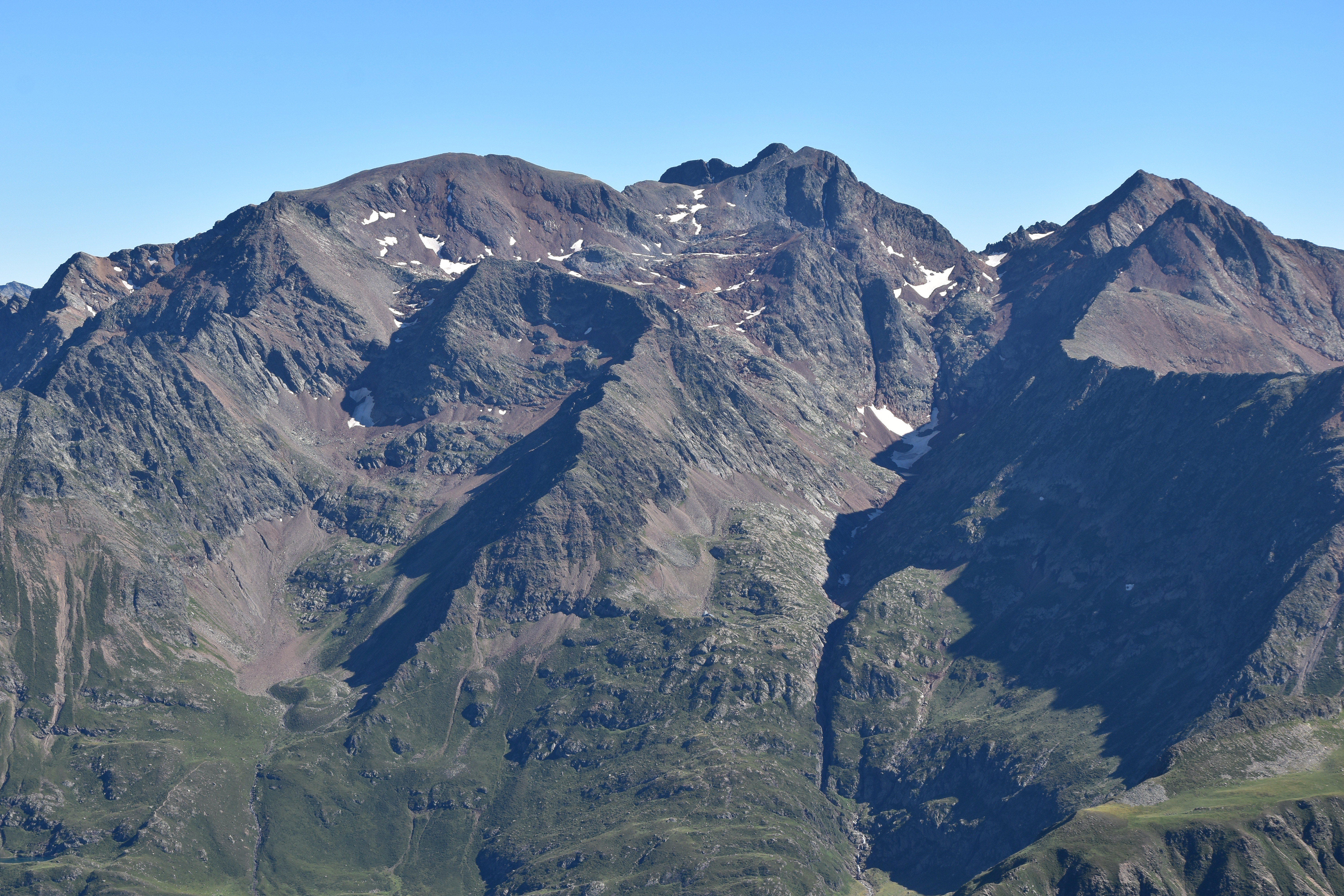
After a quick descent down to the Col de Morech (2024m), the path stretches over grassy terrain in a S, then SSW direction. After the minor top of the Cot de Morech (2145m), the terrain becomes much more uneven and demanding. There is still a distance of about 3km with some 500m ascent left. The path sticks to the edge of the ridge, with sheer drops to the W, before contouring some huge rocky outcrops from the left. A few vultures hover over the sharp Pic des Fouziès (2281m). A long rocky ridge forms a large coum to the left.


THE TOUGH, FINAL PULL-UP…
As I gain height, the ground becomes more rocky. The path meets another path right above the Etangs des Lavants de l’Escale and then disappears among the boulders that litter the E slopes of the Pic de Caumale (2523m). The going across these boulders is pretty tough and I am exhausted. And it is 4.00pm already.


But nothing can stop me now. The weather is still brilliant and I just have to give everything in the final pull-up. I need to take a breather every 20m or so, but I am getting there…


…AND FINALLY, THE ULTIMATE REWARD !!
Here I am standing at the top !! What a fantastic peak !! How could I describe what a peak-bagger feels when he reaches such a summit ? I would say the emotion is proportional both to the views and the difficulty. And that day, I must say it was huge. The 360° vista from up there is absolutely breathtaking !!


As I am still trying to catch my breath, a fell-runner appears near the summit cairn, stops for a drink and disappears in the minute. Impressive… I take dozens of photos. In the distance to the S, the Pic de Montcalm (3077m) and the Pic du Port de Sullo (3072m) stand on each side of the Pique d’Estats (3143m), the highest point in Ariège. All around me, lines and lines of sharp, rocky ridges leave me breathless. I feel I am just a tiny human being in this immensity, and every look I take around is filled with wonder and gratefulness towards Mother Nature for having letting me reach this summit, with also probably the secret prayer to keep me safe on the descent so I can tell everyone -with photos- how beautiful it was up there. And this is why I like walking on my own: I feel I am fully immersed in nature and become part of the landscape somehow, and through the effort required and the delightful views offered, find myself filled with the humility and wisdom that today’s world lacks so much. The mountains bring us back to our true dimension…


THE NEVER-ENDING DESCENT
I find out the true summit is actually just a few dozen meters from the cairn. Time to sit down for a snack and some refreshment. An alpine accentor (Prunella collaris) flutters around me. This is my first encounter with this species -which I will only identify with certainty on my return home- and another highlight of the day.


It is now 5.45pm and high time to get back to the car. After a good 30 minutes, I meet another hill-walker who is settling for the night. We chat for about 15 minutes and then I am back on the shady track. Just before the Cot de Morech, I am happy to be back in the late afternoon sunshine. Delightful lines of blue ridges line up to the W, with the prominent Mont Valier (2838m) in the background. The rest of the descent keeps following the same route as the ascent and just seems never-ending, although nice and rather easy-going. By the time I reach the car, it is already 8.30pm, i.e. about one hour before nightfall. What a fantastic day out !!

THE ROUTE
Distance: ca. 16.5km; ascent: ca. 1400m; duration: 8h45.
Difficulties: quite a long haul, but the climbing is rather gradual. The last half of the route is harder-going and orientation can be an issue, especially on the last 1.5km, in case of low visibility. Carefully check the weather forecast (beware of thunderstorms !!) and check the snow level (which may require some special equipment and competences which I do not have myself as for today), even in summer.
I enjoyed reading your detailed account; I have almost the same set of photographs and we obviously stopped at the same viewpoints! I got as far as the foot of the final climb last autumn, turning back as I’d left it too late in the day to get back before nightfall. I’m impressed that you made it after starting so late. I’m determined to get to the top another time, but it’s a loooong day!
Thank you Michelle !! Really hope you make it to the top next time as the vista is fantastic !! You may allow yourself two days to climb it if you don’t fancy doing it in one go, starting from the E and staying one night at the Refuge de Bassiès, close to the main lake.
That’s a great idea – I hadn’t thought of staying in the refuge and having a nice early start. Thanks!
Just had to let you know that I made it to the summit last week! 5 hours up and 4 down. What a fantastic summit. I enjoyed reliving it by re-reading your blog – thanks!
Fantastic, well done !! 😀 I had a two-day trip to Mont Valier last Tuesday and Wednesday, the weather was perfect indeed !!
Bravo pour ce 1er article qui met l’eau à la bouche… ou plutôt des envies de mettre un pied devant l’autre… Superbes photos.
Merci beaucoup, Dany !! See you soon !!
Great post David. Stunning scenery throughout. Love the views of the bigger mountains at the end and the layers of blue peaks.
Thank you Martin, the last pic is one of my favourite as well !!
trop bin
Merci Enzo !! 😀
Brilliant stuff David. Looks like a serious mountain – great photos too. Looking forward to more in future – subscribed now.
Thank you for your support Aidy, really happy to know you enjoyed it !! 😀
Bravo DAVID pour cet article, tu nous donnes l occasion de nous évader de notre quotidien
Merci Manu !! 😊
Merci beaucoup pour cet article ! N’ayant fait que 2 randos dans ma vie, ça me donne envie de continuer jusqu’à pouvoir en profiter seule.
Hâte de voir le prochain post !
Merci Kellhi !!
Ravi que cet article t’ait plu, n’oublie pas de t’abonner pour recevoir un notification par mail à la parution de chaque nouvel article !!
Amicalement
David