My second article will take you to the heart of the Mourne Mountains in Northern Ireland, about one hour driving distance S of Belfast. After so many trips on the Emerald Isle, it was about time for me to visit this popular area, one of the only main mountain ranges I had not yet set foot on. In my quest of climbing all of the Irish +500m summits, I had only visited two in Northern Ireland, Slieve Croob (539m) and Slieve Gullion (574m), respectively N and WSW of the Mournes. A few days’ trip last November would allow me to add a few others to my personal list…
A CHOICE OF ROUTES UNDER BEAUTIFUL NOVEMBER SKIES…
But why November ? Not the best period for hill-walking, usually wet, dull and cold and the days are short. But I have been in Ireland every year in November since 2012 and the weather has not always been that bad. The only thing is, you need an early start if you intend to complete long walks or you will have a night finish.
The Mournes are definitely the ideal place for a peak-bagger like me. The summits are relatively close to each other and most of them can be accessed with good trails -which is rather unusual in Ireland. If the weather allows, I could bag quite a few of the 35 +500m listed summits during these four days. And there is a great choice in linear routes or loops. Therefore, I will decide of my first route only on the previous night…

As I open the curtains in my hostel room, the sun is shining bright on the S slopes of Slieve Muck (674m). I have finally made my mind doing this one first and follow the ridge to the N as long as the weather, the timing and my legs will allow. It might also be interesting to visit the S top, which should offer nice views and could possibly have enough prominence to be added in the list as a “true” summit. A Full Irish and some fruit salad later, I enthusiastically hit the road to the starting point of the walk, just 10-15 minutes from the hostel.

FINE WEATHER ?
The sun is still shining, but rolling clouds have suddenly settled over Slieve Muck. No bother, I know how changing the Irish weather can be. I find a small car park along the road, just above the Spelga Reservoir, climb over the stile, and here I go !!
The faint track soon disappears. The ground becomes steeper but firmer. We are in Ireland, therefore the terrain is mainly bogland, i.e. peat more or less saturated with water, mostly covered with heather and different species of grass and moss, and knowing the “colour code” will allow you to have a notion of how firm the ground is and whether or not you are liable to get your feet wet or even remain stuck there. A generally uneven, treacherous terrain, tough -going, especially when you are walking off-track under wet conditions -which is often the case in Ireland. Climbing the Irish hills is an excellent school. The terrain and the climate can be pretty unpredictable and can easily turn a lovely hike into a nightmare. Every summit, even low, is hard-won somehow. Moreover, orienteering skills are essential.
But the beautiful light and landscapes are definitely worth the effort. One sunbeam piercing through the clouds will enhance all the colours, different shades of green contrasting with the different hues of bogland reds and yellows, the grey rock, the emerald green of the conifer plantations, the blue sky reflecting in a lough and the white and grey clouds’ shadows sweeping over the mountain slopes; just add a rainbow and you have all the ingredients of a perfect hike. And then, there are the elements. The invigorating but energy-sapping wind, the threatening rain -or hail or snow, who knows what you may get up there ?
After a mere 30 minutes, I hit the clouds. A bit disappointing when you know the sun is shining all around, but it will certainly evolve. And it feels so good to be here in the hills again !! Suddenly, like a ghost in the mist…

This is the Mourne Wall, which runs 35km along the Mournes’ main ridges. I stand amazed at this feature which has seemingly appeared from nowhere. I actually had spotted it on the map but just did not expect to meet it so early in the ascent !! And now, getting oriented will become all the more simple, as I just have to follow it to the top of Slieve Muck !!
This wall, which encircles Silent Valley, was built between 1904 and 1922 so as to prevent the sheep to access the mountainsides around Silent Valley and Ben Crom Reservoirs, so that their droppings would not spoil the water destined to human consumption. Despite a few breaches here and there, it is rather remarkably preserved and meets several other walls, as it does near the summit of Slieve Muck. I climb the stile over the secondary wall and walk to the trig point to bag my first summit in the Mournes !!


AND SUDDENLY THE VIEWS OPEN UP !!
As the summit is still covered with clouds, I almost immediately head downhill to the S, to reach this minor top which prominence I want to check. After only a few minutes I head out of the clouds into the sunshine and can admire the stunning views on both sides of the ridge !!

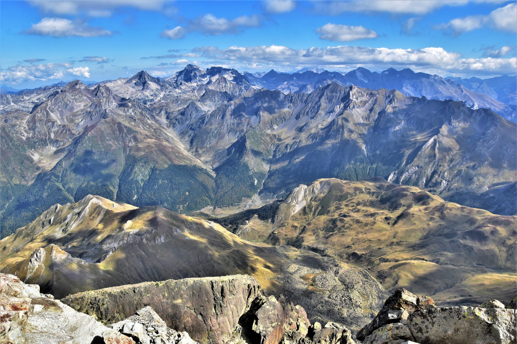
As I reach the S top (marked 626m on the OS map), I have confirmation it does not have the required 15m prominence to be added on the mountainviews.ie list. But what a fantastic vista !! To the W the never-ending Finlieve-Shanlieve-Slievemoughanmore ridge stands behind the lower Pigeon Rock ridge; to the S, the Irish Sea, with the mountains of the Cooley Peninsula visible to the SE and the modest, green hill of Knockchree down below.


But the most spectacular views are those to the E, with the unique silhouette of Slieve Binnian (746m), one of the most iconic summits of the range, its ridge continuing N to the massive bulk of Slievelamagan (702m) and further to the two highest summits of the Mournes, Slieve Donard (850m) and Slieve Commedagh (765m); down below, the two reservoirs of Silent Valley and Ben Crom can hardly be seen; the triangular shape of Ben Crom (526m); Doan stands proudly nearby with mighty Slieve Bearnagh (739m), another iconic summit of the Mournes, to the N. I actually come to realise that most of the +500m summits of the area are visible !!


I sit by the top cairn for a few minutes, sipping a cup of hot tea and enjoying the panoramic views. Then I walk back up Slieve Muck, which appears cloudless at last, and after a few minutes can enjoy the views from up there too.


FOLLOWING THE MOURNE WALL
I climb another stile over the Mourne Wall as to follow it downhill the way I came, but on the other side. The ground is rather easy-going and the rest of the route seems obvious now that the clouds have lifted. Next targets are the twin summits of Carn Mountain and Slieve Loughshannagh and I will end my walk with the short ascent up Ott Mountain (527m) and, if the weather remains dry, Butter Mountain (500m), these two standing on each side of the road which will lead me back to the car. On my way down, I wave at a group of hikers on their way to Slieve Muck. The views are so beautiful along the way that I keep stopping for pictures. These mountains are definitely photogenic !!


After an easy climb up Carn Mountain and an even easier climb up its N Top, I reach the col at the foot of Slieve Loughshannagh. This is the last “big” ascent of the day. A steep climb along a good trail, still following the wall, which just seems to roll up and down the hills like a miniature of the Great Chinese Wall…


Best is to cross over to the SE side of the wall whenever possible to reach the top of Slieve Loughshannagh. The views from its summit cairn are beautiful as well…

BUT THE WEATHER TURNS CLOUDY…
Further along the main ridge, Slieves Meelbeg (702m) and Meelmore (680m) look tempting, but the weather has turned cloudy; therefore, I will definitely end my walk with Ott Mountain (527m) and Butter Mountain (500m).
Not much climbing to reach Ott Mountain, but there is no track and the terrain is slightly uneven. I can see the group of hikers I met lately standing at the top. Hardly have they left that I reach the summit as well and can enjoy the lovely views over Spelga Reservoir.


I make my way down the N slopes to reach the farm track which leads to the road, where I catch up with the group. We exchange a few words on the Blue Quarry car park before I make my way along the steep track up Butter Mountain. No idea about where this name comes from, could it be because of his pale yellowish, grassy slopes ? Anyway, the view from up there is definitely worth the little effort.

A few minutes take me back down to the car park, which I follow to the right back to where I left the car, right on time to avoid the rain. A walk that was not too demanding, with great views all along and six summits bagged, a perfect starter before meeting my friend Daniel, who lives near Belfast, the next day, for a walk which should bring me for the first time up the highest peak of the Mournes, Slieve Donard (850m). Next episode coming soon !!
THE ROUTE
Distance: ca. 13km; ascent: ca. 750m; duration: 4h10.
This route is relatively easy in good weather conditions and physically not too demanding. Getting oriented could be an issue in the mist while off-track.
Great post and route, David. Some lovely shots. I’m very impressed at your knowledge of all the peaks in the range!
Thank you Martin, identifying the surrounding summits and features are part of the game for me 😉
super l’article !!
Merci Alex !! 😊
Brilliant stuff David – glad you got some clear weather for the views, and we got the benefit of the photos. Great shots. PS I see from mountainviews you’ve been very busy! Must have been in every corner of the country on this trip!
Thank you for your kind words Aidy, yes I usually stick to one or two regions, but this time, I have been travelling a bit indeed !! The weather has been pretty good as well, hence all the walking and not much writing !! One of the good points is, my condition has improved quite significantly (although I felt tired on my latest hike up Lug). And another one, I have a lot more to write about !! 😉
I’d say you’re right – get the walking in while you can, and the writing can wait 🙂 Looking forward to the posts though.